notes.husk.org/likes
images.
tagged satellite imagery.
page 1 of 5 with 107 images.
4 images
solar farm
solar panels
desert landscape
aerial view
renewable energy
solar array
satellite imagery
geometric pattern
solar energy
clean energy
STML
aerial photography
satellite imagery
cityscape
urban landscape
coastline
top-down view
waterfront
urban grid
blue tones
shoreline
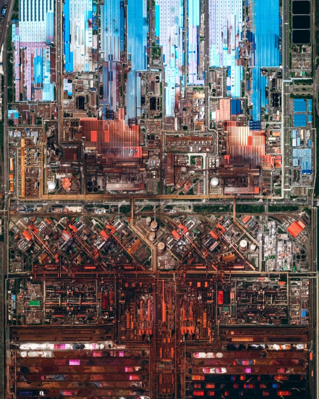
Daily Overview
aerial view
satellite imagery
industrial complex
factory
top-down perspective
manufacturing plant
infrastructure
industrial architecture
warehouse
industrial zone
Daily Overview
aerial view
coastal city
urban landscape
satellite imagery
ocean coastline
cityscape
seaside
top-down view
urban sprawl
shoreline
Daily Overview
aerial view
satellite imagery
farmland
agriculture
geometric pattern
landscape
topography
grid pattern
fields
mapping
Daily Overview
south dakota
satellite imagery
hailstorm
hail scar
missouri river
meteorology
natural disaster
remote sensing
weather patterns
earth observation
Dan W, Software Developer
satellite imagery
clouds
ocean
coastline
earth
aerial view
weather patterns
space
atmosphere
seascape
Dan W, Software Developer
satellite imagery
california
fog
mountains
ocean
aerial view
coastline
earth observation
landscape
nature
Dan W, Software Developer
aerial view
farmland
hot air balloon
agriculture
landscape
pattern
satellite imagery
fields
top-down view
geometric patterns
Dan W, Software Developer
aerial photography
satellite imagery
salt evaporation ponds
salinas
salt pans
geometric patterns
colorful landscape
mineral deposits
top-down view
urban landscape
Daily Overview
satellite imagery
night lights
earth observation
remote sensing
geospatial
aerial view
urban landscape
day and night comparison
light patterns
topography
The New Aesthetic
aerial view
satellite imagery
industrial park
warehouse district
urban landscape
commercial area
top-down view
infrastructure
cityscape
logistics center
Daily Overview
large scale banner
aerial view map
landscape print
industrial setting
large format printing
satellite imagery
massive print
textile printing
warehouse interior
scale comparison
Dan W, Software Developer
aerial view
snowy landscape
winter
geometric patterns
agricultural fields
top-down view
satellite imagery
abstract pattern
snow covered
grayscale
Tecznts
aerial view
industrial landscape
satellite imagery
shipping containers
warehouse district
logistics hub
top-down perspective
port infrastructure
manufacturing plant
geometric pattern
Dan W, Software Developer
satellite imagery
aerial view
geological feature
crater
sand ripples
dunes
topography
landscape
black and white
texture
Dan W, Software Developer
satellite imagery
meteorology
hurricane cleo
weather patterns
great lakes
tropical storm
cloud formations
earth observation
atmospheric science
monochrome
STML
abstract texture
aerial landscape
grid collage
satellite imagery
nature patterns
earth tones
topography
fluid textures
digital montage
pattern collection
Notational
aerial view
satellite imagery
evaporation ponds
lithium mining
salt flats
desert landscape
red earth
top-down view
mineral extraction
geometric patterns
Daily Overview
aerial view
satellite imagery
patchwork
green texture
agricultural fields
geometric pattern
abstract landscape
top-down view
farmland
nature pattern
Daily Overview
4 images
atmospheric science
remote sensing
satellite imagery
iss cats
cloud observation
aerosol detection
earth observation
lidar
meteorology
data visualization
Dan W, Software Developer
2 images
moon
lunar surface
craters
clementine mission
space exploration
lunar south pole
astronomy
planetary science
satellite imagery
lunar topography
STML
aerial view
satellite imagery
urban planning
circular pattern
radial design
planned community
geometric pattern
suburban landscape
urban design
residential development
Daily Overview
oil rig
offshore platform
aerial view
ocean
sea
maritime
industrial
satellite imagery
deep sea
drilling
Daily Overview